Forbes India Investigation: India's most gerrymandered constituencies
Gerrymandering is when constituency's borders are manipulated to favour a certain party
Last Updated: Apr 11, 2019, 12:25 IST5 min

According to a friend, the map of my assembly constituency (Padmanabhanagar in Bangalore South) looks like a hen doing ballet. If you think that sounds outrageous, I invite you to see the map for yourself.

If you were to say that it looks like some other creature, or plant, or concept, I wouldn’t blame you. For interpreting the shapes of assembly and parliamentary constituencies in India can be a good substitute for the Rorschach test.
Theoretically, barring national and state boundaries, and coastlines, maps of parliamentary and assembly constituencies should be convex polygons. To refresh your geometry, convex polygons are closed figures that don’t have any internal angles that are more than 180 degrees. A more rigorous definition of convex polygons is that if you select any two points at random from inside the polygon and connect them with a line segment, the entirety of the segment will lie in the interior of the polygon.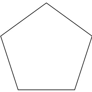
For this piece, however, you don’t need to concern yourself with so much rigour—you can think of convex polygons as polygons that don’t have weird appendages sticking out, like the Padmanabhanagar map above. Instead, convex polygons are well-formed figures, such as squares and hexagons (that said, squares and hexagons can also be non-convex, but let’s not complicate things here). For your reference, see the image of a convex polygon on the left.The main reasons constituencies in India don’t form well-formed figures is due to the concept called “Gerrymandering”. Now, there’s nothing Indian about Gerrymandering—it was first implemented byone Elbridge Gerry, who redrew the districts (constituencies) of Massachusetts state in the early 1800s to maximise his chances of re-eleciton. The shape of the district that Gerry drew was so bizarre that critics compared it to a mythical salamander, which was named “Gerrymander”.
The set of constituencies in India that will go to polls this month and the next were drawn up in the mid-2000s, based on data from the 2001 census. It is not hard to see that most constituencies have some component or the other jutting out, even when there’s no inter-state border or coastline involved. In most cases, it can be explained by some political interest or the other wanting lines drawn in a certain way to aid electoral arithmetic.  In most cases, the lines are first drawn at the most granular level (“wards” of municipal corporations, or other divisions of assembly constituencies), and then these divisions are rolled up to form assembly and parliamentary constituencies. Mathematically, it is not easy to put together a set of weird shapes and get a regular shape (unless you’re a skilled Tetris player, that is), and so assembly and parliamentary constituencies end up with weird shapes as well.
In a lot of cases, even with significant domain knowledge, it is not easy to tell which candidate or party would benefit from the way the lines on the electoral map are drawn. Nevertheless, ahead of the general elections, it would be an interesting intellectual exercise to find out which are the most gerrymandered parliamentary constituencies, and which are the states with the most gerrymandered constituencies.
To start with, we need a metric to measure how gerrymandered a constituency is. The discussion on convex polygons gives us some good intuition—what if we can draw a convex polygon around the constituency map, and see how tightly we can draw this polygon? This convex polygon will no doubt touch and coincide with the constituency map in several places, but a more gerrymandered constituency will have large areas that are within the polygon and not the constituency.
In computer science, this kind of a convex polygon that circumscribes a given area has a name—it is called a convex hull. And standardised algorithms exist to compute the convex hull of a polygon. Thus, given the shape files of a constituency (made available by the Election Commission), we can draw a tight convex polygon around each constituency, and see how much of the area of the convex polygon is occupied by the constituency. The lower this number, the more likely it is that the constituency has been gerrymandered.
This is what the four parliamentary constituencies that cover most of Bengaluru city look like:
(Black: Bangalore North Red: Bangalore Central Green: Bangalore South Blue: Bangalore Rural)
Clearly the constituency shapes are Rorschach Test-worthy—and none more so than Bangalore North (the black coloured constituency in the map). Can we see what the convex hull of Bangalore North looks like (the above map is bounded by the city limits but the below map is not. Hence the below map looks larger)?
Again you are free to draw your conclusions on what this looks like, but what is clear is that the constituency itself (white shaded region) occupies a very small portion of the enclosing (red) convex polygon. In fact, calculating areas (standard statistics packages offer easy routines to calculate areas of polygons), we find that the constituency occupies only 51 percent of the area of the enclosing polygon. This is a rather low number, with the national average being 72 percent (this excludes constituencies with more than one “component” such as Daman and Diu, or Pondicherry).
That, however, doesn’t mean that Bangalore North is the most gerrymandered constituency in India by our measure. It lies in fourth position, with the “top spot” taken by Kaliabor in Assam, which occupies just 39 percent of the area of its convex hull. Jhargram in West Bengal, whose border with Jharkhand is not sufficient reason to explain its weird shape, takes the second place.

While you try to guess what shapes these constituencies look like, we can move to finding the states with the most gerrymandered constituencies. For this, we use the same metric, but simply average it by state. Now, this measure might be biased by the fact that constituency borders necessarily need to respect state borders, and with some state borders forming weird shapes, some constituencies will necessarily look gerrymandered.
It is no surprise that Assam, which has the most gerrymandered constituency, is also the most gerrymandered state. It is no surprise either that West Bengal comes in second place. Not counting small states (with fewer than 10 constituencies), the least gerrymandered state is Madhya Pradesh, followed by Uttar Pradesh. Now that is perhaps something you would not have expected to see!


(The data for all the maps has been sourced from the Election Commission)
The author is a quant and management consultant based in Bangalore. He is also the author of "Between the buyer and the seller", a book on market structure and platforms.
First Published: Apr 11, 2019, 12:25
Subscribe Now