Explained: What caused heavy rainfall in Northwest India
The prime reason is the rare but not abnormal confluence of monsoonal winds with western disturbances. But is climate change also at play?
Last Updated: Jul 11, 2023, 14:41 IST4 min
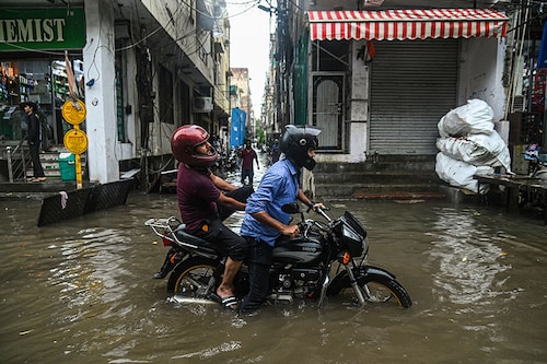
Between July 8 and 10, some areas of Northwest India, including New Delhi, Himachal Pradesh, Jammu and Kashmir, Uttarakhand, Punjab, and Rajasthan witnessed heavy to very heavy rainfall leading to landslides, flash floods, and damage to infrastructure. More than 40 people have lost their lives across these regions, and about 500 tourists continue to remain stranded in Himachal Pradesh, according to news reports.
Over 24 hours, The Safdarjung Observatory, the main weather station in New Delhi, recorded 153 mm of rain until 8.30 am on July 9, according to PTI. In four decades since July 1982, this is the highest rainfall for a single day the region has recorded.
As of today, Himachal Pradesh—so far the worst-hit state—and parts of Punjab and Haryana continued to witness rainfall. On Monday, the Indian Meteorological Department (IMD) issued a red alert—meaning ‘take action’—for several districts of Himachal Pradesh. Today, it is on an orange alert—meaning ‘be prepared’. The IMD has also issued alerts for flash floods and landslides in the state. Uttarakhand will remain on orange alert till Wednesday, July 12.
Meanwhile, authorities have started evacuating people from low-lying areas in Delhi, as the Yamuna river breached the danger mark on Monday, with Haryana releasing more water from the Hathnikund barrage.
By the end of June, the monsoon was 10 percent below the normal level. The IMD—the principal agency responsible for weather forecasting—had predicted a normal rainfall in July. However, the recent rainy spell has met the deficit for the entire country, according to the IMD. Water levels in the country’s reservoirs are also improving, the Central Water Commission told PTI.
Let’s understand the two factors, whose interaction caused the sudden spell. First, monsoonal winds, which are seasonal wind patterns that result in rain. Second, western disturbances, which are defined as extratropical storms that originate in the Mediterranean region and have a great influence on the weather of northern India. As these disturbances approach, Northwestern regions of India can witness sudden rains, a heavy cloud cover, and sometimes, even snowfall in the higher altitudes of the Himalayan region.
The recent rain episode is a rare, but not an abnormal, occurrence caused due to the interaction of the two factors stated above, which resulted in the formation of a trough above Himachal Pradesh, explains GP Sharma, president of meteorology and climate change, Skymet Weather. A trough is an elongated area of relatively low pressure, extending from the centre of a region of low pressure. It denotes bad weather in terms of clouding and rain or thundershowers. “Once the monsoon season begins, western disturbances are not active, but it is important to understand that they are not absent either," says Sharma. “Once in a while, they become active, and result in an intense spell, like this one." Hence, it would be wrong to blame every change in weather conditions on climate change, he adds.
“When this interaction happened 40 years ago, no one was talking about climate change, but it still happened," he says. “To link the current conditions with climate change, one needs to study the episode in detail and study various aspects. At a later date, one can do that. But at this moment, I will not reason this activity with climate change."
Environmental activist Sumaira Abdulali has a different opinion. “If this happened for the first time in 40 years, it could be a fluke, but the flukes are happening increasingly," she says. “Climate gives you weather, it is an overarching term for weather events, and if they say look at each occurrence as an individual weather event, we need to see the frequency as well, and it points to climate change," she says.
As someone who has lived in the country for more than 60 years, she asks, “What do you make of the fact that when I was 10, there was a certain frequency of these weather events, and today, it’s a different frequency? I don’t need to be a scientist to link different weather patterns to climate change."
Various research papers in the recent past have stated that monsoons are going to get wetter and more intense as temperatures rise, thanks to an increase in greenhouse gas emissions. The scientific jury may not attribute the recent disaster entirely to climate change, but one cannot deny that it is still a reminder to take urgent action to mitigate it and take steps to reduce emissions.
While hilly regions, and parts of Haryana and Punjab, continue to be on red and orange alerts, the IMD has said that the intensity of rains will come down in New Delhi. The region will witness light to very light rainfall this week, it added. According to the agency, the monsoon trough is moving further north, and the impact will most likely be felt in the Himalayan foothills.
First Published: Jul 11, 2023, 14:41
Subscribe Now